

Top 100 Countries and Territories by Coral Reef Area, 2026
Countries and territories with the largest coral reef area
Coral reef area is the mapped surface of shallow, warm-water reef systems lying within a country's or territory's waters, measured in square kilometres. It sets the geographic baseline for conservation planning, coastal-protection assessment, blue-economy analysis and reef-risk screening.
Reef area is not the same thing as live coral cover, reef health or biodiversity. A jurisdiction can rank high simply because it has broad tropical shelves, atolls or overseas reef territories, while still facing heavy pressure from heat stress, pollution, overfishing, cyclones and coastal development.
The 2026 label is a current snapshot, not a fresh annual census. The headline numbers come from a public compiled table (World Population Review); UNEP-WCMC and the Allen Coral Atlas are used here for methodological context, not for row-by-row verification of each figure.
Continue exploring
More StatRanker rankings on climate, environment, resources and sustainability.
Top 100 Largest Countries by Land Area, 2026 Snapshot
Open rankingCountries and Territories by Biodiversity Hotspot Overlap, 2026 Snapshot
Open rankingTop 20 Countries by Protected Marine Area, 2026
Open rankingSummary cards
Indonesia leads the table because the archipelago sits at the centre of the Coral Triangle, the most reef-rich region on Earth.
The lower tail holds small reef jurisdictions and maximum-estimate bands. These rows are useful for coverage, not for fine-scale comparison.
The list mixes sovereign states, territories and reef jurisdictions, because several major reef systems are governed as overseas or non-sovereign territories.
Larger mapped area ranks higher. Values are rounded and describe reef extent, not reef condition.
Overview
The top of the ranking is shaped by geography, not by income or population. Large tropical archipelagos, broad continental shelves, Red Sea coastlines, atoll nations and overseas reef territories dominate, because reefs only form in shallow, warm, sunlit water.
Indonesia, Australia and the Philippines form a clear top tier. Behind them sit countries with major Pacific, Indian Ocean, Caribbean or Red Sea systems. Many small island states rank far higher than their land area would suggest, while several large economies sit low because only a fraction of their coastline supports warm-water reefs.
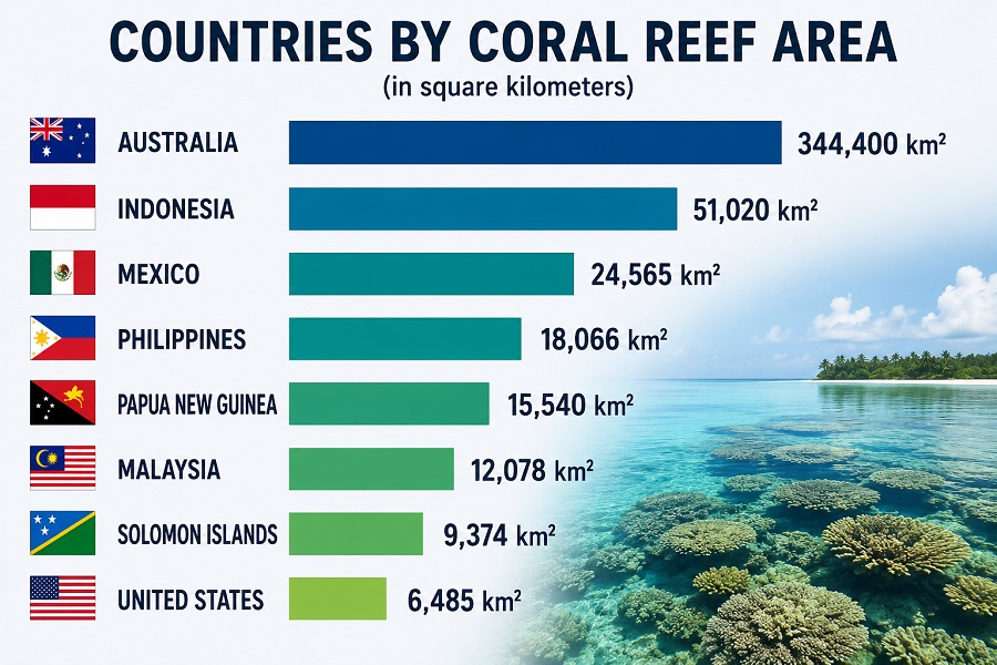
Top 20 countries and territories by coral reef area
The Top 20 is heavily Indo-Pacific, though the Red Sea, Caribbean and Indian Ocean are also represented. Sovereign records for countries with overseas reefs are kept as country-level totals, unless a specific territory is listed separately further down the table.
| Rank | Country / territory | Coral reef area | Region / note |
|---|---|---|---|
| 1 | Indonesia | 51,020 km² | Asia-Pacific |
| 2 | Australia | 48,960 km² | Oceania |
| 3 | Philippines | 25,060 km² | Asia-Pacific |
| 4 | France | 14,280 km² | Overseas reef jurisdictions |
| 5 | Papua New Guinea | 13,840 km² | Asia-Pacific |
| 6 | Fiji | 10,020 km² | Oceania |
| 7 | Maldives | 8,920 km² | Indian Ocean |
| 8 | Saudi Arabia | 6,660 km² | Red Sea |
| 9 | Marshall Islands | 6,110 km² | Oceania |
| 10 | India | 5,790 km² | Indian Ocean |
| 11 | Solomon Islands | 5,750 km² | Oceania |
| 12 | United Kingdom | 5,510 km² | Overseas reef jurisdictions |
| 13 | Micronesia | 4,340 km² | Oceania |
| 14 | Vanuatu | 4,110 km² | Oceania |
| 15 | Egypt | 3,800 km² | Red Sea |
| 16 | United States | 3,770 km² | Pacific / Caribbean |
| 17 | Malaysia | 3,600 km² | Asia-Pacific |
| 18 | Tanzania | 3,580 km² | East Africa |
| 19 | Eritrea | 3,260 km² | Red Sea |
| 20 | Bahamas | 3,150 km² | Caribbean |
Values are rounded. Composite sovereign records such as France, the United Kingdom, the United States, the Netherlands and New Zealand reflect overseas reef jurisdictions, in line with the country-level compiled table.
Chart: Top 20 coral reef areas
The chart scales each of the first twenty entries against Indonesia, set as the 100% reference bar. The steep drop after the top three shows how concentrated large reef extent is within a handful of archipelagic and continental-shelf systems.
Methodology
The indicator measures mapped coral reef area in square kilometres. It is a spatial-extent measure: reef polygons or reef pixels are summed within each country, territory or reef jurisdiction. More area means more mapped reef surface — not healthier reefs.
Measurement logic
Coral reef area is the summed surface of shallow, warm-water reef systems. The ranking runs in descending order: the larger the mapped area, the higher the position.
Snapshot year
The page uses a 2026 publication snapshot. Reef-extent datasets are not annual censuses, so a single baseline can stay valid for area comparison even as reef condition shifts from year to year.
Rounding and harmonisation
Values are rounded to the nearest 10 km² or 1 km², depending on source precision. Entries at 100 km² or below are treated as maximum-estimate bands and carry more uncertainty.
Limits
The metric says nothing about live coral cover, bleaching, fish biomass, biodiversity, water quality, management effectiveness, tourism value or coastal-protection performance.
The headline ranking uses World Population Review, a public compiled table, as its numeric baseline. UNEP-WCMC and the Allen Coral Atlas provide methodological context — they were not used to re-verify each row. The two traditions can diverge sharply. UNEP-WCMC's Global Distribution of Coral Reefs is a baseline map assembled from several sources, including the Millennium Coral Reef Mapping Project and the World Atlas of Coral Reefs, while the Allen Coral Atlas builds global habitat maps with satellite-based bleaching and turbidity monitoring — a different mapping logic that can yield substantially different area totals. So totals differ between datasets, driven by reef definitions, mapping resolution, depth limits and boundary-attribution rules.
Full ranking: Top 100 countries and territories by coral reef area
Use the controls to search by country, filter by region, sort the values or switch between the Top 10, Top 20 and the full list.
| Rank | Country / territory | Coral reef area | Region / note |
|---|---|---|---|
| 1 | Indonesia | 51,020 km² | Asia-Pacific |
| 2 | Australia | 48,960 km² | Oceania |
| 3 | Philippines | 25,060 km² | Asia-Pacific |
| 4 | France | 14,280 km² | Overseas reef jurisdictions |
| 5 | Papua New Guinea | 13,840 km² | Asia-Pacific |
| 6 | Fiji | 10,020 km² | Oceania |
| 7 | Maldives | 8,920 km² | Indian Ocean |
| 8 | Saudi Arabia | 6,660 km² | Red Sea |
| 9 | Marshall Islands | 6,110 km² | Oceania |
| 10 | India | 5,790 km² | Indian Ocean |
| 11 | Solomon Islands | 5,750 km² | Oceania |
| 12 | United Kingdom | 5,510 km² | Overseas reef jurisdictions |
| 13 | Micronesia | 4,340 km² | Oceania |
| 14 | Vanuatu | 4,110 km² | Oceania |
| 15 | Egypt | 3,800 km² | Red Sea |
| 16 | United States | 3,770 km² | Pacific / Caribbean |
| 17 | Malaysia | 3,600 km² | Asia-Pacific |
| 18 | Tanzania | 3,580 km² | East Africa |
| 19 | Eritrea | 3,260 km² | Red Sea |
| 20 | Bahamas | 3,150 km² | Caribbean |
| 21 | Cuba | 3,020 km² | Caribbean |
| 22 | Kiribati | 2,940 km² | Oceania |
| 23 | Japan | 2,900 km² | Asia-Pacific |
| 24 | Sudan | 2,720 km² | Red Sea |
| 25 | Madagascar | 2,230 km² | Indian Ocean |
| 26 | Thailand | 2,130 km² | Asia-Pacific |
| 27 | Myanmar | 1,870 km² | Asia-Pacific |
| 28 | Mozambique | 1,860 km² | East Africa |
| 29 | Mexico | 1,780 km² | Caribbean / Pacific |
| 30 | Seychelles | 1,690 km² | Indian Ocean |
| 31 | China | 1,510 km² | Asia-Pacific |
| 32 | Tonga | 1,500 km² | Oceania |
| 33 | Belize | 1,330 km² | Caribbean |
| 34 | New Zealand | 1,310 km² | Pacific territories |
| 35 | Vietnam | 1,270 km² | Asia-Pacific |
| 36 | Jamaica | 1,240 km² | Caribbean |
| 37 | Brazil | 1,200 km² | Atlantic |
| 38 | United Arab Emirates | 1,190 km² | Gulf |
| 39 | Palau | 1,150 km² | Oceania |
| 40 | Costa Rica | 970 km² | Americas |
| 41 | Colombia | 940 km² | Caribbean / Pacific |
| 42 | Taiwan | 940 km² | Asia-Pacific |
| 43 | Mauritius | 870 km² | Indian Ocean |
| 44 | Honduras | 810 km² | Caribbean |
| 45 | Panama | 720 km² | Americas |
| 46 | Somalia | 710 km² | East Africa |
| 47 | Nicaragua | 710 km² | Caribbean / Pacific |
| 48 | Tuvalu | 710 km² | Oceania |
| 49 | Iran | 700 km² | Gulf |
| 50 | Yemen | 700 km² | Red Sea / Gulf of Aden |
| 51 | Qatar | 700 km² | Gulf |
| 52 | Sri Lanka | 680 km² | Indian Ocean |
| 53 | Kenya | 630 km² | East Africa |
| 54 | Dominican Republic | 610 km² | Caribbean |
| 55 | Bahrain | 570 km² | Gulf |
| 56 | Oman | 530 km² | Gulf / Arabian Sea |
| 57 | Samoa | 490 km² | Oceania |
| 58 | Venezuela | 480 km² | Caribbean |
| 59 | Netherlands | 470 km² | Caribbean territories |
| 60 | Haiti | 450 km² | Caribbean |
| 61 | Djibouti | 450 km² | Red Sea / Gulf of Aden |
| 62 | Comoros | 430 km² | Indian Ocean |
| 63 | Antigua and Barbuda | 240 km² | Caribbean |
| 64 | Brunei | 210 km² | Asia-Pacific |
| 65 | American Samoa | 200 km² | Territory estimate |
| 66 | Saint Kitts and Nevis | 180 km² | Caribbean |
| 67 | Saint Lucia | 160 km² | Caribbean |
| 68 | Grenada | 150 km² | Caribbean |
| 69 | Saint Vincent and the Grenadines | 140 km² | Caribbean |
| 70 | Kuwait | 110 km² | Gulf |
| 71 | Singapore | 100 km² | Maximum estimate band |
| 72 | Trinidad and Tobago | 100 km² | Maximum estimate band |
| 73 | Barbados | 100 km² | Maximum estimate band |
| 74 | Dominica | 100 km² | Maximum estimate band |
| 75 | Puerto Rico | 90 km² | Territory estimate band |
| 76 | Guam | 85 km² | Territory estimate band |
| 77 | U.S. Virgin Islands | 80 km² | Territory estimate band |
| 78 | Northern Mariana Islands | 75 km² | Territory estimate band |
| 79 | Bangladesh | 50 km² | Maximum estimate band |
| 80 | Ecuador | 50 km² | Maximum estimate band |
| 81 | Cambodia | 50 km² | Maximum estimate band |
| 82 | Jordan | 50 km² | Maximum estimate band |
| 83 | Nauru | 50 km² | Maximum estimate band |
| 84 | Turks and Caicos Islands | 45 km² | Territory estimate band |
| 85 | British Virgin Islands | 40 km² | Territory estimate band |
| 86 | Anguilla | 35 km² | Territory estimate band |
| 87 | Cayman Islands | 35 km² | Territory estimate band |
| 88 | Montserrat | 30 km² | Territory estimate band |
| 89 | Bermuda | 25 km² | North Atlantic |
| 90 | Aruba | 20 km² | Territory estimate band |
| 91 | Curaçao | 20 km² | Territory estimate band |
| 92 | Bonaire | 20 km² | Territory estimate band |
| 93 | Sint Maarten | 15 km² | Territory estimate band |
| 94 | Saint Barthélemy | 15 km² | Territory estimate band |
| 95 | Saint Martin | 15 km² | Territory estimate band |
| 96 | Israel | 10 km² | Red Sea |
| 97 | Cook Islands | 10 km² | Territory estimate band |
| 98 | Niue | 8 km² | Territory estimate band |
| 99 | Tokelau | 8 km² | Territory estimate band |
| 100 | Wallis and Futuna | 8 km² | Territory estimate band |
Rows at 100 km² or below are maximum-estimate bands. They are included for geographic coverage and should not be read as precise reef measurements.
Insights
Key Insight
Within this World Population Review baseline, Indonesia and Australia together account for about 35% of the listed global total — more than 99,000 km². Their lead comes from sheer archipelagic and continental-shelf scale.
Notable Pattern
Reef area tracks neither population nor GDP. Small island states such as Fiji, the Maldives, the Marshall Islands, Kiribati and Palau rank high because maritime geography outweighs land size.
Regional Concentration
The Indo-Pacific and Oceania fill the upper half. The Caribbean, Red Sea, Indian Ocean and East Africa recur, but their largest entries stay well below the leading Coral Triangle and Pacific systems.
Outlier
France, the United Kingdom and the United States rank high mainly through overseas territories — New Caledonia and French Polynesia for France, the Chagos Archipelago for the UK, the Pacific and Caribbean islands for the US — not through their mainland coasts.
What It Means
For conservation managers, a larger mapped reef area means a larger area to monitor and protect. It does not mean the reefs are intact: big systems can be heavily exposed to marine heatwaves, runoff, destructive fishing and tourism pressure.
For policymakers, reef area sets the scale of marine spatial planning, fisheries management, coastal protection and restoration budgets. Extensive reefs demand not only protected areas but enforcement, water-quality control and climate-risk planning.
For blue-economy analysts, reef extent is a baseline for tourism, fisheries and natural-infrastructure exposure. It is most useful alongside hazard data, reef condition, governance capacity and adaptation indicators rather than on its own.
For students and researchers, the ranking is a starting map. The next layer of analysis is live coral cover, bleaching frequency, local threats, protected-area effectiveness and community dependence.
FAQ
Which country has the largest coral reef area?
Indonesia ranks first, with 51,020 km² of mapped coral reef. That position reflects the scale of the Indonesian archipelago and its location at the heart of the Coral Triangle.
Does coral reef area mean live coral cover?
No. Reef area is a mapped geographic extent. Live coral cover measures the share of that surface occupied by living corals, and it can fall sharply after bleaching, storms or local stress.
Why is the 2026 ranking based on mapping baselines rather than a 2026 census?
Global reef extent is updated through mapping products, not annual field counts. The 2026 label means the page is a current snapshot built on the latest comparable public baselines available for global comparison.
Why are territories included?
Many reef systems lie in overseas or non-sovereign territories. Leaving them out would weaken the ranking for conservation purposes, since reef management is usually tied to territorial jurisdictions.
Why do different sources report different reef areas?
Estimates vary with reef definition, map resolution, depth threshold, how lagoons and geomorphic classes are treated, and boundary-attribution rules. High-resolution datasets often produce different totals from older atlas-based compilations.
Does a larger reef area mean a healthier reef?
No. A large reef system can be badly degraded, and a small one can be well managed. Area should be read together with live coral cover, bleaching exposure, local threats and management data.
What is the difference between reef extent and coral habitat?
Reef extent usually covers the broader shallow reef structure. Coral habitat is a narrower class, limited to areas likely to support living coral communities. Allen Coral Atlas work shows coral habitat can be far smaller than total shallow reef area.
Why do small island states rank so high?
Atolls, barrier reefs and broad shallow shelves can give a small island jurisdiction an enormous reef area relative to its land or population. That is why reef rankings look so different from economic or demographic ones.
Sources
Related rankings
More StatRanker rankings on climate, environment, resources and sustainability.
Countries by Forest Area per Person ТОП-100, 2026
Open rankingTop 100 Countries by Forest Area per Capita, 2025
Open rankingTop 100 Countries by Share of Land in Protected Areas, 2025
Open rankingTop 100 Countries by Threatened Mammal and Bird Species Count, 2026 Snapshot
Open rankingStatRanker (Website)
administrator