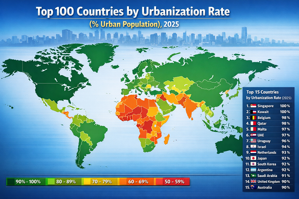

Top 10 megacities by population and density
Top 10 megacities by population and density in 2025
The 2025 picture looks different from many older “largest city” lists because the ranking here is built on contiguous built-up urban agglomerations, not city-proper borders and not broader administrative metros. Once neighbouring urban footprints are treated as a single functional urban mass, the leaderboard changes sharply: Guangzhou–Shenzhen and Shanghai–Changzhou now rank ahead of Tokyo–Yokohama.
Population and density also answer different questions. Population shows urban scale; density shows how tightly that scale is packed into land. A megacity can be enormous because it spreads across a huge multi-core footprint, or it can be smaller in total population but far more compressed. That is why Mumbai and Dhaka stand out so strongly once average density is considered alongside total size.
2025 update at a glance
The main shift is methodological, not merely demographic. The 2025 built-up-area edition broadens the treatment of adjacent urban footprints and combines nearby urban areas where continuous urbanization now forms a single urban system. This matters especially in China, where large neighbouring urban areas are now read as one integrated footprint.
The result is a more realistic view of urban scale for transport, labour markets and land-use analysis. It also means that older rankings with Tokyo firmly in first place are no longer current under the built-up-area lens used here.
Table. Top 10 megacities by population in 2025, with average density
| Rank | Megacity (built-up urban area) | Population, 2025 | Density (people/km²) |
|---|---|---|---|
| 1 | Guangzhou–Shenzhen | 69,562,000 | 6,541 |
| 2 | Shanghai–Changzhou | 45,115,000 | 4,636 |
| 3 | Tokyo–Yokohama | 37,325,000 | 4,254 |
| 4 | Jakarta | 36,877,000 | 10,400 |
| 5 | Delhi | 33,224,000 | 14,174 |
| 6 | Mumbai | 26,237,000 | 24,588 |
| 7 | Manila | 25,521,000 | 13,352 |
| 8 | Dhaka | 25,305,000 | 23,374 |
| 9 | Seoul–Incheon | 23,825,000 | 8,605 |
| 10 | Cairo | 22,684,000 | 8,413 |
Chart 1. Population scale of the top 10 megacities
The updated ranking underlines the overwhelming weight of Asia in global megacity formation. The top ten are all in Asia except Cairo, and the first five already show how different megacity growth paths can be: China’s multi-core corridors, Japan’s mature urban giant, Indonesia’s vast capital region and India’s dense growth pole.
Population fallback:
- Guangzhou–Shenzhen — 69.6M
- Shanghai–Changzhou — 45.1M
- Tokyo–Yokohama — 37.3M
- Jakarta — 36.9M
- Delhi — 33.2M
- Mumbai — 26.2M
- Manila — 25.5M
- Dhaka — 25.3M
- Seoul–Incheon — 23.8M
- Cairo — 22.7M
Chart 2. Density within the same top-10 group
Density reshuffles the story. Mumbai and Dhaka are not the two biggest megacities by total population, but they are the most compressed in this top-10 set. Tokyo–Yokohama, by contrast, remains one of the world’s largest urban systems while posting a much lower average density because its built-up footprint is so extensive.
Density fallback:
- Mumbai — 24,588 people/km²
- Dhaka — 23,374 people/km²
- Delhi — 14,174 people/km²
- Manila — 13,352 people/km²
- Jakarta — 10,400 people/km²
- Seoul–Incheon — 8,605 people/km²
- Cairo — 8,413 people/km²
- Guangzhou–Shenzhen — 6,541 people/km²
- Shanghai–Changzhou — 4,636 people/km²
- Tokyo–Yokohama — 4,254 people/km²
Methodology
The unit of analysis is the built-up urban agglomeration: a contiguous or mostly contiguous urban footprint functioning as an integrated economic unit. This is not the same as a municipality, a city-proper boundary or a broad administrative metro. That distinction is the single most important reason why rankings of “largest cities” differ so much across sources.
The core numerical base used here is Demographia World Urban Areas 2025, which reports population, land area and average population density for built-up urban areas using a consistent cross-country framework. The 2025 edition explicitly broadens the treatment of adjacent urban footprints and combines nearby urban areas where urbanization has become continuous. This is especially relevant for China, where Guangzhou–Shenzhen and Shanghai–Changzhou are now treated as single built-up systems.
A second methodological caution concerns comparability with the United Nations urban agglomeration series. The UN framework is official and indispensable for demographic analysis, but it measures a different spatial object from the built-up-area lens used in this page. That is why a UN-based ranking may place Jakarta, Dhaka and Tokyo at the top, while a built-up-area ranking yields a different order.
How to read the numbers: population shows the scale of the whole urban footprint; density shows how tightly that footprint is occupied on average. Neither metric alone captures quality of life, congestion, affordability or infrastructure performance.
Insights and interpretation
The first clear pattern is that megacity growth is increasingly regional and polycentric, not simply city-centric. Guangzhou–Shenzhen and Shanghai–Changzhou are not just large cities that expanded; they are now urban corridors where multiple major centres, commuting flows and built-up zones effectively merge into one giant system. That matters for planning because governance often remains fragmented long after the physical city has already fused.
The second pattern is that density and prosperity are not the same story. Mumbai and Dhaka rank near the top on density, but that does not automatically mean efficient urban form or high infrastructure quality. Very high density can reflect constrained land supply, informal settlement pressure, limited housing stock per household and overloaded utilities just as much as it can reflect compactness.
The third pattern is that mature megacities often spread scale across more land. Tokyo–Yokohama shows how a very large, long-developed urban system can remain one of the biggest in the world while looking less dense on average than newer or more land-constrained megacities. The contrast between Tokyo and Dhaka is especially useful: both are globally significant urban giants, but they operate through very different spatial structures.
Finally, the ranking highlights how much of the global urban future is concentrated in Asia. Even within this one region, however, the urban models are radically different: East Asian multi-core corridors, South Asian ultra-dense settlements, Southeast Asian capital-centric systems and highly networked metropolitan regions. The category “megacity” is therefore too broad unless readers also look at density, land area and settlement form.
What this means for readers
For a general reader, the ranking helps separate two ideas that are often mixed together in media coverage: how large a city is and how crowded it is on average. A megacity can be huge because it covers an enormous urban footprint, or intense because it compresses a very large population into limited land. Those are different urban realities.
For relocation, investment or business expansion, this matters because market size and land pressure are not interchangeable. A giant urban area usually implies a deeper labour pool and larger consumer base; higher density often signals stronger pressure on transport systems, housing, utilities and land values. Together, these metrics give a better first read on urban operating conditions than population alone.
For policy and planning, the main lesson is that megacity management increasingly means managing whole urban regions rather than isolated municipal cores. Transport, housing, water, logistics and air quality all operate at the scale of the real built-up footprint, not the formal line on a city map.
FAQ
Why is Tokyo no longer number one in this version?
Because this page uses the 2025 built-up-area methodology that combines adjacent urban footprints where they function as one continuous urban system. Under that lens, Guangzhou–Shenzhen and Shanghai–Changzhou move above Tokyo–Yokohama.
Why do UN megacity rankings sometimes look different?
Because the UN urban agglomeration series uses a different spatial definition. Official UN lists are essential for demographic work, but they do not measure exactly the same urban unit as the built-up-area approach used here.
Does higher density mean a city is better planned?
No. High density can support shorter trips and stronger transit viability, but it can also reflect housing pressure, constrained land supply and overloaded infrastructure. Density is a condition, not a quality score.
Why is Mumbai denser than Tokyo in this table?
The comparison covers the whole built-up footprint. Tokyo spreads a very large population over a much larger mature urbanized area, while Mumbai compresses its population into substantially less land.
Are city centres and suburbs both included?
Yes. The measure covers the full built-up urban agglomeration where development is contiguous or mostly contiguous. That is why average density is usually lower than what people imagine from central business districts alone.
What is the best use of this ranking?
It is most useful for comparing urban scale and land pressure across countries in a consistent way. It is a good starting point for discussion of sprawl, housing, infrastructure strain, transport planning and multi-core urban growth.
Sources
All source items below are fully clickable. They open the underlying methodology or statistical reference used to interpret the ranking.
Core source for built-up urban area population, land area and density. This article’s ranking and chart values are based primarily on this edition.
Open Demographia World Urban Areas 2025Official United Nations urban agglomeration reference used here for methodological contrast and to explain why alternative megacity rankings may differ.
Open UN World Urbanization Prospects 2025Public summary page that reproduces the 2025 UN urban agglomeration ranking and offers a concise cross-check for the official UN ordering.
Open Destatis megacity summaryUpdate basis: 2025 estimates. This page is an analytical StatRanker-style comparison, not an official national statistical release.